Heat Waves, Floods, Wildfires, Snow: California Endures Extremes - What Should We Do
 |
| Extreme Weather & Climate Exchange |
Summary of California Climate Extremes in 2024
1. Heat Waves:
- Prolonged periods of extreme heat affected much of California, with temperatures frequently reaching triple digits.
- Some areas like the Mojave Desert saw highs up to 114°F (45.6°C), the San Joaquin Valley up to 111°F (43.9°C), and Death Valley up to 125°F (51.7°C).
- The heat waves lasted for extended periods, with little relief at night in many areas.
2. Wildfires:
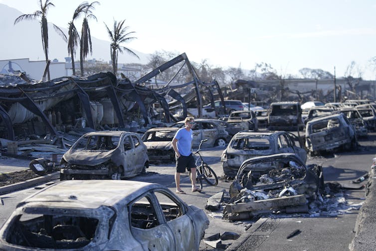
- California experienced significant wildfire activity, with several large fires burning across the state.
- The Park Fire became California's fourth-largest fire on record, burning over 671 square miles.
- Dry conditions and gusty winds associated with weather systems increased fire danger throughout the season.
3. Unusual Snow Events:
- In a rare occurrence, snow fell in August at high elevations in California, including Lassen Volcanic National Park and the Sierra Nevada.
- This unusual summer snow led to the closure of parts of Highway 89 and affected areas like Mammoth Mountain and Minaret Vista.
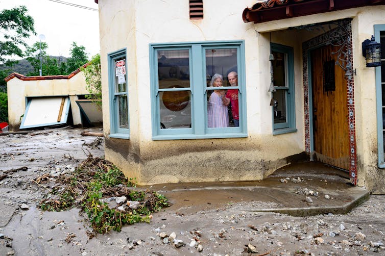
4. Flooding and Storms:
- California experienced severe storms and flooding events throughout the year.
- Atmospheric rivers caused flooding and mudslides on the West Coast at the beginning and end of the year.
- In an extremely rare event, a tropical storm hit California in August.
5. Drought and Water Issues:
- While not explicitly mentioned for 2024, the context suggests ongoing concerns about drought and water management, particularly given the extreme heat events.
6. Temperature Records:
- Several temperature records were broken across the state during heat waves.
7. Economic Impact:
- These extreme weather events had significant economic consequences, including damage to infrastructure, agricultural losses, and increased energy demand.
8. Climate Change Context:
- The extreme events were largely attributed to the ongoing effects of climate change, with 2023 noted as the warmest year on record globally, setting the stage for continued extremes in 2024.
This summary highlights the diverse and severe weather extremes California faced in 2024, ranging from intense heat and wildfires to unusual snow events and flooding, all occurring within the context of a changing climate.
How Climate Change is Intensifying California's Weather Extremes
While California has historically experienced various weather extremes, climate change is amplifying these events and altering weather patterns in several key ways:
- Increased Average Temperatures
- The overall warming trend raises baseline temperatures, making heat waves more frequent, intense, and longer-lasting.
- Higher temperatures increase evaporation rates, exacerbating drought conditions.
- Changes in Precipitation Patterns
- Climate change is altering atmospheric circulation patterns, affecting the timing and distribution of rainfall.
- This can lead to more intense periods of drought followed by extreme precipitation events.
- Intensification of the Water Cycle
- Warmer air can hold more moisture, leading to more intense rainfall events when conditions are right.
- This contributes to an increased risk of flooding and mudslides, especially after periods of drought.
- Snow Pack Reduction
- Higher temperatures mean more precipitation falls as rain rather than snow in mountainous areas.
- This affects water storage in snowpack and alters the timing of water availability throughout the year.
- Sea Level Rise
- Rising sea levels increase the risk of coastal flooding and erosion.
- This can exacerbate the impacts of storm surges during extreme weather events.
- Wildfire Risk
- Higher temperatures and drought conditions dry out vegetation, creating more fuel for wildfires.
- Changes in wind patterns can also contribute to the spread of fires.
- Extreme Weather Variability
- Climate change can lead to more pronounced swings between extremes, such as rapid transitions from drought to flooding.
- Ocean Warming
- Warmer ocean temperatures can influence coastal weather patterns and potentially increase the intensity of storms.
- Jet Stream Changes
- Alterations in the jet stream due to Arctic warming can lead to more persistent weather patterns, including prolonged heat waves or cold snaps.
These factors combine to create a more volatile and extreme climate system, pushing California's weather patterns beyond their historical norms and intensifying the impacts of extreme events.
Heat Waves, Wildfires, Snow: California Endures a Summer of Extremes - Times of San Diego

An unusually cold weather system from the Gulf of Alaska interrupted summer along the West Coast on Saturday, bringing snow to mountains in California and the Pacific Northwest and prompting the closure of part of a highway that runs through a national park.
Parts of Highway 89 through Lassen Volcanic National Park in California were shut down after an estimated 3 inches of snow fell overnight, according to the National Weather Service.
Photos posted by the agency and local authorities showed a high-elevation blanket of white on Mount Rainier in Washington along with a dusting of snow at Minaret Vista, a lookout point southeast of Yosemite National Park in California’s Sierra Nevada.
Madera County Deputy Sheriff Larry Rich said it was “definitely unexpected” to see snow at Minaret Vista in August.
“It’s not every day you get to spend your birthday surrounded by a winter wonderland in the middle of summer,” he said in a statement. “It made for a day I won’t soon forget, and a unique reminder of why I love serving in this area. It’s just one of those moments that makes working up here so special.”
In northern Nevada, rain fell in the runup to the annual Burning Man festival, prompting organizers to close the entrance gate for most of Saturday before reopening. Torrential rains upended last year’s festival, turning the celebration and its temporary city into a muddy quagmire.
It also snowed overnight on Mammoth Mountain, a ski destination in California, with the National Weather Service warning hikers and campers to prepare for slick roads.
Record rainfall moved through Redding, Red Bluff and Stockton in Northern California on Saturday, the weather service said, and rain showers south of Lake Oroville were expected to continue into the evening.
A dusting of snow fell overnight on the crest of the Sierra Nevada around Tioga Pass, the weather service said. August snow has not occurred there since 2003, forecasters said.
Tioga Pass rises to more than 9,900 feet and serves as the eastern entryway to Yosemite. But it is usually closed much of each year by winter snow that can take one or two months to clear.
While the start of ski season is at least several months away, the hint of winter was welcomed by resorts.
“It’s a cool and blustery August day here at Palisades Tahoe, as a storm that could bring our first snowfall of the season moves in this afternoon!” the resort said in a social media post Friday.
The “anomalous cool conditions” will spread over much of the western U.S. by Sunday morning, according to the National Weather Service’s Weather Prediction Center in College Park, Maryland.
Despite the expected precipitation, forecasters also warned of fire danger because of gusty winds associated with the passage of the cold front.
At the same time, a flash flood watch was issued for the burn scar of California’s largest wildfire so far this year from Friday morning through Saturday morning.
The Park Fire roared across more than 671 square miles after it erupted in late July near the Central Valley city of Chico and climbed up the western slope of the Sierra.
The fire became California’s fourth-largest on record, but it has been substantially tamed recently. Islands of vegetation continue to burn within its existing perimeter, but evacuation orders have been canceled.
The state’s wildfire season got off to an intense start amid extreme July heat. Blazes fed on dried-out vegetation that grew during back-to-back wet years. Fire activity has recently fallen into a relative lull.
Forecasts call for a rapid return of summer heat as the cold front departs.
Thunderstorms during California's heat wave causing flood, fire risk - Los Angeles Times
California’s latest heat wave has drawn tropical moisture into the region, causing severe thunderstorms in some inland areas that forecasters warn could continue to cause flash flooding and dangerous lightning through at least Wednesday night.
Some areas of Southern California, including the San Gabriel mountains and ranges across San Bernardino County, have the potential for strong, slow-moving storms to develop Wednesday afternoon. The storms “may produce heavy rainfall amounts and some flash flooding,” the National Weather Service warned.
The Sierra Nevada and surrounding foothills also have a high risk for severe thunderstorms, with a chance for excessive rainfall causing flooding across much of eastern and southeastern California, according to the the National Weather Service’s Weather Prediction Center.
“In recent days, even isolated storms have been able to produce flooding due to the sensitivity of the soils in those areas,” forecasters at the Weather Prediction Center warned. “Thus, isolated flash flooding is likely, ... though exactly where that happens is very difficult to say.”
A section of Mono County remains under a flood watch through Wednesday night, and forecasters warn that “excessive runoff from thunderstorms may result in flooding of burn scars, creaks, streams and other low-lying and flood-prone locations.”
This monsoonal moisture driving the storms is a fairly typical summer weather pattern that occurs due to a change in wind currents, said Stephen McCoy, a meteorologist with the National Weather Service in Hanford.
“We have an upper-level high-pressure system that’s currently located over southern Nevada,” McCoy said. “The rotation around this high-pressure system is driving moisture up from the tropics into our area.”
That high-pressure system continues to heat up the region, with most of the Central Valley and interior Southern California under excessive heat warnings through Thursday evening.
Temperatures across the state are expected to remain in the triple digits, with highs in the Mojave Desert forecast to reach up to 114 degrees; in the San Joaquin Valley, highs could hit 111, in the Antelope Valley up to 110 and in Death Valley up to 125. Forecasters continue to warn that little relief will come at night, with low temperatures remaining above 70 or 80 in many areas.
With the heat and thunderstorms, there’s an increased risk for wildfires, especially if there’s dry lightning.
Storms on Tuesday caused over 1,500 lightning strikes across the San Bernardino, Riverside and San Diego county mountains and deserts, and even more were recorded in northeastern Los Angeles County and over the Sierra Nevada. However, officials said most of those strikes hit during a wet storm, as will likely be the case Wednesday.
“Yesterday and today, we have had the lightning but it’s been associated with rainfall,” McCoy said Wednesday morning. “The fire potential isn’t as high as it has been in the past,” but it’s certainly still a risk.
Dry lightning has already been linked to at least four fires that ignited Monday in the Plumas National Forest, forcing some evacuations in nearby resort towns. The Gold fire complex had grown to a total 2,858 acres as of Wednesday, with warnings that structures remain threatened and evacuations “could increase depending on fire growth and behavior,” the U.S. Forest Service said in an update.
Federal officials fighting the fire there said the cooling trend expected to begin later this week should help temper the blaze, but noted that Wednesday’s chance for thunderstorms could bring “gusty, erratic winds which can cause unpredictable fire spread.”
The crews have not yet reached any containment on the Gold fire complex.
In Los Padres National Forest, the Apache fire ignited Tuesday and forced some nearby evacuations, according to Ventura County Fire Department officials. Burning about 30 miles northeast of Ojai, the blaze continued to grow Wednesday, estimated at about 800 acres. It wasn’t immediately clear the cause of that fire. No containment has been established there.
But with the amount of moisture in the atmosphere, weather officials said flash flooding will be the largest threat Wednesday.
“The big concern that we have today, alongside the lightning strikes, is a slight risk for potential flooding,” McCoy said.
Heat waves, wildfires and now … snow? California endures a summer of extremes
Updated 6:36 PM PDT, August 24, 2024
SACRAMENTO, Calif. (AP) — An unusually cold weather system from the Gulf of Alaska interrupted summer along the West Coast on Saturday, bringing snow to mountains in California and the Pacific Northwest and prompting the closure of part of a highway that runs through a national park.
Parts of Highway 89 through Lassen Volcanic National Park in California were shut down after an estimated 3 inches (7.6 centimeters) of snow fell overnight, according to the National Weather Service.
Photos posted by the agency and local authorities showed a high-elevation blanket of white on Mount Rainier in Washington along with a dusting of snow at Minaret Vista, a lookout point southeast of Yosemite National Park in California’s Sierra Nevada.
Madera County Deputy Sheriff Larry Rich said it was “definitely unexpected” to see snow at Minaret Vista in August.
“It’s not every day you get to spend your birthday surrounded by a winter wonderland in the middle of summer,” he said in a statement. “It made for a day I won’t soon forget, and a unique reminder of why I love serving in this area. It’s just one of those moments that makes working up here so special.”
In northern Nevada, rain fell in the runup to the annual Burning Man festival, prompting organizers to close the entrance gate for most of Saturday before reopening. Torrential rains upended last year’s festival, turning the celebration and its temporary city into a muddy quagmire.
It also snowed overnight on Mammoth Mountain, a ski destination in California, with the National Weather Service warning hikers and campers to prepare for slick roads.
Record rainfall moved through Redding, Red Bluff and Stockton in Northern California on Saturday, the weather service said, and rain showers south of Lake Oroville were expected to continue into the evening.
A dusting of snow fell overnight on the crest of the Sierra Nevada around Tioga Pass, the weather service said. August snow has not occurred there since 2003, forecasters said.
Tioga Pass rises to more than 9,900 feet (3,017 meters) and serves as the eastern entryway to Yosemite. But it is usually closed much of each year by winter snow that can take one or two months to clear.
While the start of ski season is at least several months away, the hint of winter was welcomed by resorts.
“It’s a cool and blustery August day here at Palisades Tahoe, as a storm that could bring our first snowfall of the season moves in this afternoon!” the resort said in a social media post Friday.
The “anomalous cool conditions” will spread over much of the western U.S. by Sunday morning, according to the National Weather Service’s Weather Prediction Center in College Park, Maryland.
Despite the expected precipitation, forecasters also warned of fire danger because of gusty winds associated with the passage of the cold front.
At the same time, a flash flood watch was issued for the burn scar of California’s largest wildfire so far this year from Friday morning through Saturday morning.
The Park Fire roared across more than 671 square miles (1,748 square kilometers) after it erupted in late July near the Central Valley city of Chico and climbed up the western slope of the Sierra.
The fire became California’s fourth-largest on record, but it has been substantially tamed recently. Islands of vegetation continue to burn within its existing perimeter, but evacuation orders have been canceled.
The state’s wildfire season got off to an intense start amid extreme July heat. Blazes fed on dried-out vegetation that grew during back-to-back wet years. Fire activity has recently fallen into a relative lull.
Forecasts call for a rapid return of summer heat as the cold front departs.
___
Antczak reported from Los Angeles. Associated Press writer Morgan Lee in Santa Fe, New Mexico, contributed to this report.
2023’s extreme storms, heat and wildfires broke records – a scientist explains how global warming fuels climate disasters
The year 2023 was marked by extraordinary heat, wildfires and weather disasters.
In the U.S., an unprecedented heat wave gripped much of Texas and the Southwest with highs well over 100 degrees Fahrenheit (37.8 Celsius) for the entire month of July.
Historic rainfall in April flooded Fort Lauderdale, Florida, with 25 inches of rain in 24 hours. A wave of severe storms in July sent water pouring into cities across Vermont and New York. Another powerful system in December swept up the Atlantic coast with hurricane-like storm surge and heavy rainfall. The West Coast started and ended the year with flooding and mudslides from atmospheric rivers, and California was hit in August by a tropical storm – an extremely rare event there.
Wildfires ravaged Hawaii, Louisiana and several other states. And Canada’s worst fire season on record sent thick smoke across large parts of North America.
Globally, 2023 was the warmest year on record, and it wreaked havoc around the world. El Niño played a role, but global warming is at the root of the world’s increasing extreme weather.
So, how exactly is global warming linked to fires, storms and other disasters? I am an atmospheric scientist who studies the changing climate. Here’s what you need to know.
Dangerous heat waves and devastating wildfires
When greenhouse gases, such as carbon dioxide from vehicles and power plants, accumulate in the atmosphere, they act like a thermal blanket that warms the planet.
These gases let in high-energy solar radiation while absorbing outgoing low-energy radiation in the form of heat from the Earth. The energy imbalance at the Earth’s surface gradually increases the surface temperature of the land and oceans.
The most direct consequence of this warming is more days with abnormally high temperatures, as many countries saw in 2023.
Extreme heat waves hit large areas of North America, Europe and China, breaking many local high temperature records. Phoenix went 30 days with daily high temperatures at 110 F (43.3 C) or higher and recorded its highest minimum nighttime temperature, with temperatures on July 19 never falling below 97 F (36.1 C).
Although heat waves result from weather fluctuations, global warming has raised the baseline, making heat waves more frequent, more intense and longer-lasting.
That heat also fuels wildfires.
Increased evaporation removes more moisture from the ground, drying out soil, grasses and other organic material, which creates favorable conditions for wildfires. All it takes is a lightning strike or spark from a power line to start a blaze.
Canada lost much of its snow cover early in 2023, which allowed the ground to dry and vast fires to burn through the summer. The ground was also extremely dry in Maui in August when the city of Lahaina, Hawaii, caught fire during a windstorm and burned.
How global warming fuels extreme storms
As more heat is stored as energy in the atmosphere and oceans, it doesn’t just increase the temperature – it can also increase the amount of water vapor in the atmosphere.
When that water vapor condenses to liquid and falls as rain, it releases a large amount of energy. This is called latent heat, and it is the main fuel for all storm systems.
When temperatures are higher and the atmosphere has more moisture, that additional energy can fuel stronger, longer-lasting storms. This is the main reason for 2023’s record-breaking storms. Nineteen of the 25 weather and climate disasters that caused over US$1 billion in damage each through early December 2023 were severe storms, and two more were flooding that resulted from severe storms.
Tropical storms are similarly fueled by latent heat coming from warm ocean water. That is why they only form when the sea surface temperature reaches a critical level of around 80 F (27 C).
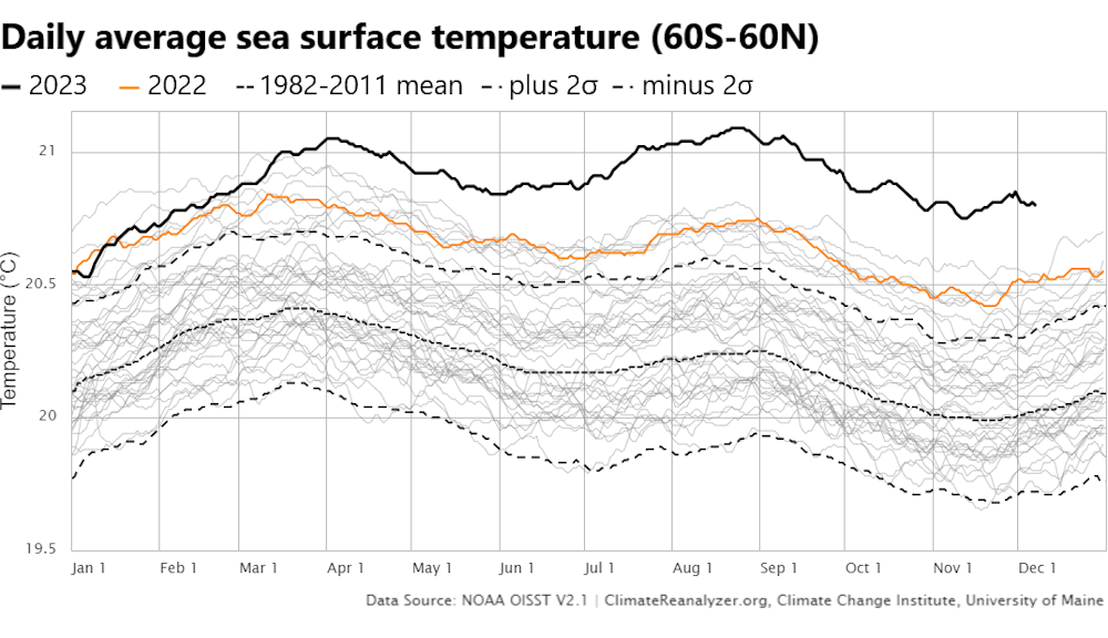
With 90% of the excess heat from global warming being absorbed by the ocean, there has been a significant increase in the global sea surface temperature, including record-breaking levels in 2023.
Higher sea surface temperatures can lead to stronger hurricanes and longer hurricane seasons. They can also lead to the faster intensification of hurricanes.
Hurricane Otis, which hit Acapulco, Mexico, in October 2023, was a devastating example. It exploded in strength, rapidly intensifying from a tropical storm to a destructive Category 5 hurricane in less than 24 hours. With little time to evacuate and buildings not designed to withstand a storm that powerful, more than 50 people died. The hurricane’s intensification was the second-fastest ever recorded, exceeded only by Hurricane Patricia in 2015.
A recent study found that North Atlantic tropical cyclones’ maximum intensification rates increased 28.7% between the 1971-1990 average and the 2001-2020 average. The number of storms that spun up from a Category 1 storm or weaker to a major hurricane within 36 hours more than doubled.
The Mediterranean also experienced a rare tropical-like cyclone in September 2023 that offers a warning of the magnitude of the risks ahead – and a reminder that many communities are unprepared. Storm Daniel became one of the deadliest storms of its kind when it hit Libya. Its heavy rainfall overwhelmed two dams, causing them to collapse, killing thousands of people. The heat and increased moisture over the Mediterranean made the storm possible.
Cold snaps have global warming connections, too
It might seem counterintuitive, but global warming can also contribute to cold snaps in the U.S. That’s because it alters the general circulation of Earth’s atmosphere.
The Earth’s atmosphere is constantly moving in large-scale circulation patterns in the forms of near-surface wind belts, such as the trade winds, and upper-level jet streams. These patterns are caused by the temperature difference between the polar and equatorial regions.
As the Earth warms, the polar regions are heating up more than twice as fast as the equator. This can shift weather patterns, leading to extreme events in unexpected places. Anyone who has experienced a “polar vortex event” knows how it feels when the jet stream dips southward, bringing frigid Arctic air and winter storms, despite the generally warmer winters.
In sum, a warmer world is a more violent world, with the additional heat fueling increasingly more extreme weather events.
The toll of extreme heat is rising in California - Los Angeles Times
As California heads into a dangerous holiday heat wave that will blanket millions of residents in triple-digit temperatures, state and federal officials are vowing to do more to address the worsening threat — and the rising costs — of extreme heat.
On Tuesday, the U.S. Department of Labor’s Occupational Safety and Health Administration, or OSHA, announced that it will advance a proposed rule to protect indoor and outdoor workers from high temperatures at the national level. If finalized, the regulations would establish temperature-based standards for an estimated 35 million workers in places such as warehouses, kitchens, farms and construction sites.
The proposal, which has been in the works since 2021, would apply to workplaces where the heat index regularly rises above 80 degrees, according to senior administration officials. It would follow similar moves by California, which in 2006 became the first state in the nation to establish permanent heat protections for outdoor workers and just last month approved heat regulations for indoor workers.
Officials said such rules are needed as extreme heat claims more lives and as the nation grapples with more frequent and severe weather events fueled by climate change. Last year, the U.S. saw a record 28 disasters that exceeded $1 billion in losses, which caused more than $90 billion in aggregate damage.
At the same time, California’s Department of Insurance this week released a first-of-its kind analysis revealing $7.7 billion in insurance losses tied to extreme heat events over the last decade. The report quantifies the uninsured and insured costs of seven recent extreme heat events in the state and highlights the need for adaptive strategies.
It joins a growing body of evidence about extreme heat’s toll — from mounting heat-related illnesses and fatalities to biodiversity impacts, economic effects, agricultural losses and infrastructure damage. Heat has contributed to more deaths over the last 30 years than hurricanes, floods and tornadoes combined, making it the deadliest of all U.S. climate hazards, according to the National Weather Service. Last year was the planet’s hottest year ever recorded.
“Extreme heat is a silent, escalating disaster that threatens our health, economy, and way of life in California,” read a statement from Insurance Commissioner Ricardo Lara. “This report brings to light the staggering hidden costs of extreme heat events, underscoring the urgency of our efforts to create a groundbreaking heat wave ranking and early warning system statewide. We must prioritize resilience-building efforts and innovative insurance solutions to safeguard our state against the growing impacts and financial risks of extreme heat.”
Indeed, experts have for years been pushing for more stringent surveillance of heat’s toll, with a 2021 Los Angeles Times investigation revealing that extreme heat deaths are chronically undercounted in the state. Following that investigation, Gov. Gavin Newsom signed into law a bill to create a heat wave ranking system similar to those used for hurricanes. The system is slated to be in place by Jan. 1, 2025.
Newsom also in recent years launched an extreme heat awareness campaign, urban greening programs and other efforts to help residents prepare for and adapt to worsening heat; however some of those programs received cuts amid this year’s budget deficit.
Though the $7.7-billion cost associated with heat events is substantial, the Department of Insurance estimated that the true toll is likely higher. While some kinds of insurance do cover costs connected to extreme heat — such as health coverage, workers’ compensation insurance and crop insurance — there are gaps that will require new mechanisms and investments, the agency said. The state is currently facing a separate insurance crisis related to worsening wildfires.
Other costs associated with heat include labor productivity losses, which ranged from $7.7 million to $210 million per event, according to the report. Infrastructure repair costs due to heat-related damage ranged from $3.8 million to $35 million per event, predominantly affecting roads and rails, while power outages during heat waves resulted in substantial economic impacts up to $230 million.
One of the heat events covered in the report — a prolonged heat wave in September 2022 — pushed California’s power grid to the brink and prompted an emergency text message from the state’s energy operators asking residents to conserve power, narrowly avoiding a blackout.
That same heat wave was later determined to have killed 395 Californians, according to state health officials, who also reported that its worst effects were among Latinos and working-age people between 25 and 64.
The Department of Insurance’s report similarly underscored the ways in which extreme heat disproportionately affects communities of color, low-income communities and vulnerable populations such as seniors and children.
Jonathan Parfrey, executive director of Climate Resolve, said the report’s admittedly conservative estimates are “nonetheless staggering.”
“A hot day is not just an inconvenience — for hundreds of thousands of Californians, extreme heat is a matter of life and death,” Parfrey said, adding that the losses in labor productivity alone should be a wake-up call to industry and policymakers. “The lesson is this: Investing in cooling solutions today will save money and lives tomorrow.”
But strengthening workplace protections will also help save lives, White House officials said.
OSHA’s proposed rule, which will be sent to the federal register and made available for public comments, would require workplaces to establish heat-illness and injury-prevention plans that are evaluated at least once a year; to provide workers with access to drinking water and cool-down areas and to respond to symptoms of heat illness and emergencies, among other measures.
Additional protections would be triggered at temperatures of 90 degrees or higher, including mandatory rest breaks and symptom monitoring.
States such as California, which already have workplace heat regulations in place, would have to meet the minimum federal requirements but could go further, officials said. States such as Florida and Texas — which have passed laws blocking cities or employers from establishing heat rules — would also have to comply with the federal rule or face significant penalties for violations.
The proposed rule joins other efforts from the Biden administration to address worsening heat and climate hazards, including a new heat risk tool from the National Weather Service, cooling assistance programs for low-income households and expanded investments in trees and green spaces.
The Federal Emergency Management Agency on Tuesday also announced that it will make available $1 billion in funding for its Building Resilient Infrastructure and Communities program to help communities reduce their risk from disasters and natural hazards, including extreme heat, wildfires, droughts, hurricanes, earthquakes and floods.
The funding includes 656 projects across the nation, including considerable investments in disadvantaged communities, agency officials said.
However, FEMA continues to face pressure from environmental groups and labor organizations urging it to broaden its definition of “major disasters” to include extreme heat, which advocates say would unlock additional avenues of funding during heat waves and help states and communities better prepare for rising temperatures.
Already this year, FEMA and other federal agencies have responded to more than a dozen disasters, including devastating wildfires in New Mexico and historic flooding in Iowa and Minnesota, officials said.
They are currently monitoring Hurricane Beryl — which became the first hurricane on record to reach Category 4 in the month of June — as well as the record-breaking heat slated to smother much of the country this week.
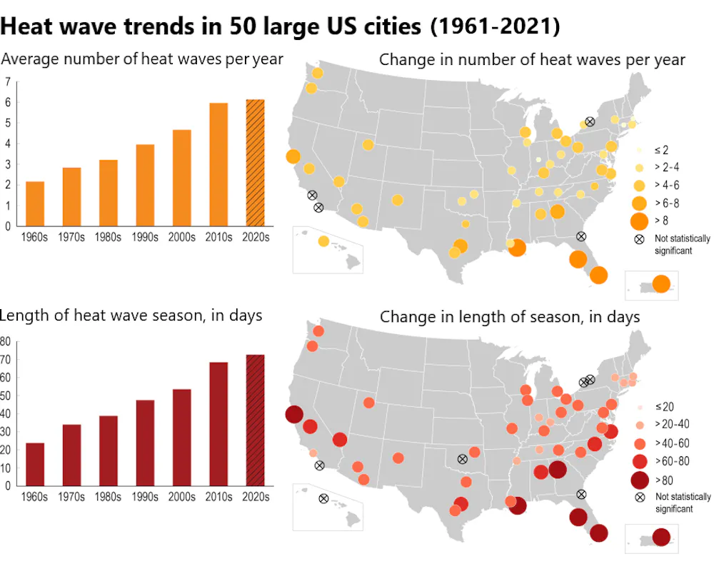
But heat waves continue to pose unique dangers, with the average length of the heat wave season now 46 days longer than it was in the 1960s, according to a new report from the U.S. Environmental Protection Agency.
In California, officials warned that the incoming heat wave could lead to wildfires as soaring temperatures coincide with fireworks, barbecues and other Fourth of July-related activities. State officials are warning that power shutoffs are possible in some Northern California counties, where temperatures could soar as high as 110 degrees.
Portions of the Central Valley and the Antelope Valley might also climb to 110 degrees, while the Coachella Valley could bake at 121 degrees and Death Valley at 125 degrees.
The heat wave is expected to linger for days, forecasters said — with some parts of the Golden State not likely to see relief until at least the start of next week.


Comments
Post a Comment